
Looking at Mapgo (https://www.mapgo.io/): what price would make it a no-brainer for you, and at what price would you stop considering it? What would you expect to get for that money? Also say the maximum you would pay per month in USD (0 if nothing).
Page reviewed
MapGO: GIS File Converter, Distance Tools & Property Reports
https://www.mapgo.io/ (opens in a new tab)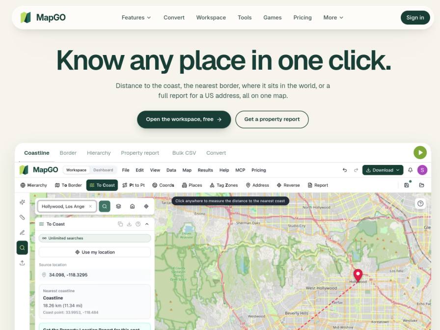
10 fictional AI personas. Exploratory perspectives, not a survey of real customers. Methodology & limitations
Simulated interest
AI synthesis, not measured demand
Suggested price range
Median $45 · simulated willingness to pay
Response sentiment
What this panel suggests
These synthetic answers show moderate interest in MapGO, mainly because the product solves practical GIS chores: converting files, measuring distances, and looking up place hierarchy. The strongest positive reactions center on time savings and convenience for shapefiles, GeoJSON, KML, and similar workflows. The main drag is pricing clarity. Several respondents said the page makes the offering hard to evaluate because it references 'plans & credits' without showing obvious monthly pricing. That uncertainty is more of a buying-friction issue than a rejection of the product. The US-only property report feature also narrows appeal for international users, although the global map tools themselves still resonate. At the same time, respondents expect more than basic access for a paid plan: API access, bulk CSV processing, reliable conversion limits, and trustworthy data accuracy. Across the synthetic sample, the implied willingness-to-pay center is about $45/month, with a lower no-brainer zone around $20 and an upper ceiling near $75 for richer use cases. The overall read is: useful tool, but the pricing page needs to make value and limits much more explicit.
Pricing & positioning
Lead with a clearly published monthly tier, then layer credits only for heavier usage. The synthetic responses point to a comfortable zone around $20-$45/month, with stronger resistance near $75 unless the plan includes API access, bulk CSV processing, reliable conversion limits, and enough report/lookup volume to feel predictable.
The biggest friction is not the core utility; it is pricing opacity. Respondents liked the GIS conversion and distance tools, but several hesitated because the page mentions 'plans & credits' without obvious monthly pricing. A clearer entry tier would help anchor value, especially for individual GIS users, analysts, and light automation use. The US-only scope of property reports narrows the appeal, so pricing should separate global map tools from report-heavy use cases.
Recurring themes
“The ability to convert between various GIS file formats, especially KML and Shapefiles, without manual intervention sounds very promising for saving me time”Read Jaime Casper’s response →
“The ability to convert shapefiles and GeoJSON, along with distance calculations to features like coastlines and borders, is certainly appealing for my daily tasks.”Read Gwen Wuckert’s response →
“The pricing for MapGO isn't immediately clear, as it refers to 'plans & credits' without showing them.”Read Tamina Morhelfer’s response →
“I would expect robust API access and reliable data accuracy for that price.”Read Garuda Jha’s response →
Objections to investigate
- Unclear pricing structure
- US-only property reports limitation
- Cost escalation risk with credits
- Budget constraints for personal/nonprofit users
Use these findings to plan customer interviews or experiments. How to interpret AI research
What the panel said
Click a name to open that persona’s full profile.
Gwen WuckertneutralThe ability to convert shapefiles and GeoJSON, along with distance calculations to features like coastlines and borders, is certainly appealing for my daily tasks. If it offered robust data validation tools that could help catch errors from consultants early on, I'd consider a price point around $50 per month. For that, I'd expect a seamless conversion process, detailed reporting on data integrity, and perhaps integration capabilities with QGIS. Anything above $100 per month would push me to re-evaluate if the time savings justify the cost, especially given our team's current software budget limitations.
Simulated interest: 70/100
Jaime CasperneutralThe ability to convert between various GIS file formats, especially KML and Shapefiles, without manual intervention sounds very promising for saving me time, given the data we receive. I’d need to see how robust the conversion is in practice, particularly with complex datasets. If it reliably handles different projections and attribute tables without errors, and offers bulk processing, I might consider it. For the file conversion and basic distance lookups, perhaps up to $50 per month would be a reasonable starting point. However, the property reports are US-only, which limits their immediate use for my UK-based work. I would need to understand the pricing structure for credit packs for more intensive use, but I'm hesitant given the lack of clear pricing on the page for the core services beyond 'free to start' or pay-as-you-go credits.
Simulated interest: 30/100
Garuda JhapositiveMapGO's tools for distance calculations and file conversions are quite relevant to my work. Being able to quickly check travel distances or convert formats would save me significant time, especially given the amount of data cleaning I do. If it offered comprehensive bulk processing and seamless integration with our existing PostGIS setup, a price around $50 per month would be compelling. Anything over $150 would be a stretch, as I'd need to justify it against other operational tools and consider my personal budget. I would expect robust API access and reliable data accuracy for that price.
Simulated interest: 75/100
Tamina MorhelferneutralThe pricing for MapGO isn't immediately clear, as it refers to 'plans & credits' without showing them. If I could get unlimited access to their conversion tools for shapefiles and GeoJSON, along with global distance and border calculations, I'd consider a no-brainer price around $50 per month. Anything above $100 per month would make me pause, especially if the property reports are only for the US, as my work is primarily in Germany and neighboring countries. I need to understand the specifics of the 'credits' and what constitutes a 'limit' before making a firm decision.
Simulated interest: 40/100
Adalard LouisneutralMapGO presents an interesting proposition, particularly the ability to convert GIS files and perform distance calculations. For my work, the core value would be in its data processing capabilities. A "no-brainer" price for me would be around $30 per month, which would grant access to bulk CSV conversion and potentially the property report features for the US market, as we sometimes analyze international retail trends. I'd expect robust API access and reliable, fast processing. If it exceeded $70 per month, or if the property reports were limited to just the US without any clear path to broader international data, I would cease to consider it. I would not pay for features that are already readily available in our existing GIS software.
Simulated interest: 60/100
Rachel ProhaskaneutralThis MapGO platform seems to offer some interesting tools, especially the property report feature. However, I'm accustomed to my manual process, which, while time-consuming, has always worked for me. I'd need to see a significant time savings or a considerable reduction in manual effort to justify the cost. If I could get comprehensive property reports, including flood zones and utility data, for around $25 per month, I might consider it. Anything over $50 a month would be too much, as my current expenses are minimal and I prefer to keep them that way for financial security.
Simulated interest: 30/100
Dewey CronaneutralThe file conversion tools seem useful, especially supporting KML and GPX. My main concern is data consistency from our survey crews, so anything that automates or simplifies that is a plus. A no-brainer price for me would be around $20 USD per month, perhaps including a certain number of file conversions or lookups. If it started creeping towards $50 USD per month for similar functionality, I'd have to seriously reconsider if it's worth the cost versus the time saved, especially given my current income and the fact that this would be a personal subscription, not company-funded.
Simulated interest: 60/100
Winifred WolffneutralThe property report feature looks promising for our work in understanding neighborhood conditions for grants. If a "no-brainer" price meant I could get bulk processing for our parcel lists and property reports for at least 100 addresses per month, I'd be looking at something around $50-$75. Anything over $100 per month would be a hard sell, given our tight nonprofit budget and the fact that we're currently relying on free tools. I'd expect reliable data sources for those reports and flexible export options for the bulk CSV.
Simulated interest: 70/100
Kasper DriessenneutralThe concept of quickly checking distances to coastlines or borders, and converting between GIS formats, is potentially useful for our work, especially when dealing with municipal projects that might involve port proximity or regional boundaries. However, the pricing isn't immediately clear from the page. I would expect a "no-brainer" price to be around $20-30 per month, offering a generous allowance for file conversions and a good number of distance lookups. Anything above $50 per month would make me hesitate, especially considering we already invest in other GIS tools. If the pricing is primarily based on pay-as-you-go credits, the cost could quickly escalate for our needs, making it not a clear value proposition without understanding the credit costs per operation. For regular use, I'd be looking for a subscription that covers our typical weekly analysis needs without constant worry about exceeding limits. I wouldn't pay more than $40 per month for this service.
Simulated interest: 50/100
Divya ShuklapositiveMapGO looks interesting, especially the file conversion and distance calculation tools, which could definitely help with the messy data my brokers send. A 'no-brainer' price would be around $20-$30 per month, maybe $50 if it consistently handles bulk CSVs and integrates smoothly with our existing spreadsheets. For that, I'd expect robust file conversion for various GIS formats and reliable distance/hierarchy lookups for any location. Anything over $100 per month would make me pause, as that's pushing into enterprise territory, and I'd need to see a much more comprehensive feature set or dedicated support for that cost. I'm not sure about a maximum monthly price in USD as the pricing page itself is not fully detailed, but I would not pay more than $75 per month.
Simulated interest: 70/100
Keep exploring.
Find your next question or see which topics divide AI panels.
What would you ask next?
Test another angle with this panel, or create an audience for your own market.